The original map is with the Norwich Records Office, Ref no. MC22/11.
A full size copy of the complete map is displayed in New Buckenham’s village hall,
funded by the New Buckenham Society and the High Bailiff’s Charity in 2010.
The Society is most grateful to Paul Rutledge for his scholarly description of the map.
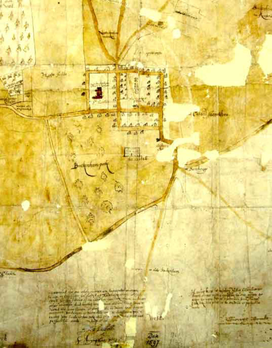
1597 map
This is a copy of a map made as evidence in one of the
squabbles between New Buckenham and Carleton
Rode about commons.
New Buckenham claimed common as far as the
crossroads and Carleton claimed to share the bit
between the present end of the common and the
crossroads. Carleton eventually won.
The top of the map is to the east, towards Carleton
Rode, but we begin at the west end where the castle is
shown in its wooded park. Beside it is Clifton’s
cha[pel] and the Dambrigge then a simplified plan of
New Buckenham (no Marsh Lane!) with stalls
on the market place and the church ‘called St Martins’.
Then the common with the old claypits (still to be
seen), the beck described as the ‘fall of the water from
the woods’, Spitle crofte (perhaps the site or the
property of a medieval spittal or hospice), and an old
mill hill (still visible just south of the common), then
the Haugh field, New Buckenham’s big town field, ‘in sundrie parcelles’. The road to Tibenham,
long ago gone, is also marked. The eastern (top) boundary that is now Cherry Tree Road and
Upgate is shown in especial detail as the area ‘at variaunce’. It had various names; procession way
because of beating the bounds, green way, and Hundred mere because it was the boundary of the
ancient boundary of Shropham. Other names include ostroke and Goldlocks corner, perhaps
marking outstanding oak trees. There is also a sheep mere, a sheep watering place (mere had two
meanings, boundary and pool). Returning on the north side another shared field, High Field,
then a big wood called Harling Wood otherwise known as Buckenham Wood (Harling because it
had once belonged to the manor of East Harling), then the boundary passes down by Wattes
Lane, now Harlingwood Lane, through a green called Condals green and also through the middle
of the former parish church of St Andrew ‘now a barne’ which was somewhere on the site of Old
Buckenham Stud. The procession lane brings us back to the Dambrigge whose name means
embanked causeway. ‘Carleton Common 1000 acres’ is noted wryly at the top left-hand corner of
the sheet.
H

© The New Buckenham Society 2015 (rev 2023)
Can you identify people or dates, or add a photo?
or
Cookies are used to link to Google Analytics and Facebook but this site collects no personal information


- Brief history of village
- A moated town
- William Barber's almshouses
- History of village school 1848-1912
- New Buckenham: the history of a market town
- Historic buildings research report (NHBG)
- History of individual properties
- Rogationtide in the 1590s
- Who was Boosey?
- New Buckenham in 1542
- Newspaper articles
- Prince Duleep Singh's photographs
- Vicarage